
EOSS Upcoming Flights
-
05/18/2024 - 07:00 to 14:30
-
08/03/2024 - 00:00 to 23:45
-
10/19/2024 - 00:00 to 23:45
-
11/02/2024 - 00:00 to 23:45
-
11/09/2024 - 00:00 to 23:45
Tracking Grids
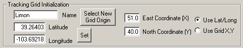
On the first tab of the Setup Screen (in the lower right corner) is this dialog. You can use this entry method in two basic ways.
One, you could just directly type in the name, latitude and longitude (or use the Set button to enter lat/long) and set east and north coordinates.
Or you could click "Select New Grid Origin". In this case, BT will open a file called "gridsites.ini". If it does not exist, it will be created when you use the add feature of that dialog box. Once you have entered several Grid locations you may discover you are reusing them in the future. For some more detailed instructions on how this "Select" option works see the explanations of items on the Locations tab of the setup screen.
East and North coordinates are NOT saved in the gridsites.ini file (they are in each BT INI file) because while the latitude and longitude of a location never changes (hopefully) the relationship it bears to a grid overlay may (probably) will change from flight to flight.
If you check "Use Lat/Long" the program will continue to display data as it always did. However, if you click "Use Grid X,Y" then on the main screen the columns for latitude and longitude will be replaced by Grid X,Y coordinates. On the synopsis screen the lat/long data will be replaced by Grid X,Y data. On any printouts, when "Use Grid X,Y" is checked then BOTH the Grid and Lat/Long data is shown in the synopsis part of the printout, however, the individual lat/longs in the tabular data is replaced by the Grid X,Y data.
All these settings are saved in the INI file.
What is a Grid?
Edge of Space Sciences has been using a Grid Overlay DFing system for around 8 years. The way it works is quite simple.
A grid was designed that could be printed on transparencies that would show a mile by mile grid. Actually, the major divisions are in 5 mile increments, with only tick marks denoting the individual miles. (see the EOSS tracking grid overlay here)
The grid must be designed with a particular map in mind (or at least one of a specific scale) so that the mileage will match from grid to map.
Of course, the grid could be used on any common map regardless of scale, however, we use several computer programs (BT now joining that group) that rely on the actual mileage figures to calculate lat/long positions so, in reality, we always stick with one common map for the RDF team.
Prior to a flight, with reasonably dependable flight predictions in hand, the grid is placed on the map. Several prominent locations are identified on the grid and this information is shared as an easy way for others to align their grids. On a recent flight we set the Grid with these coordinates:
- Limon 51,40
- Karval 60,3
- Tructon 25,35
- Kiowa 10.5,45.75
- Launch Point 5.75, 45
- Landing Point 71.5,21.5
Anyone with the grid, and the map it is designed for, can quickly float the grid over the map, align the reference points and affix the grid to the map.
During a flight, RDF teams locate themselves on the grid by their X,Y coordinates and give a bearing. It goes something like:
Net Control: "Bravo?"
Station Bravo: "Station Bravo, 39 comma 24, 240 degrees true, N0KKZ"
This means, station Bravo is 39 miles east of the grid origin and 24 miles north of that point and the bearing to the transmitter is 240 degrees. We always add the word "True" to remind ourselves and all other stations to convert from Magnetic bearings to True. In the event that we get REALLY spread out, this ensures all bearings are aligned to a common frame of reference. It also helps in computing stuff.
In that one brief report station bravo acknowledges the net control station, identifies his current position and indicates which direction he believes the transmitter is located, signing the transmission with his callsign.
We have a spread sheet where this data is quickly input, and after several stations have reported, a triangulation is generated.
Adding this User Grid system to Balloon Track might only benefit EOSS, but your group might look into this DFing system as a way to simplify field operations during recovery efforts.