
EOSS Upcoming Flights
-
05/04/2024 - 00:00 to 23:45
-
05/18/2024 - 07:00 to 14:30
-
08/03/2024 - 00:00 to 23:45
-
10/19/2024 - 00:00 to 23:45
-
11/02/2024 - 00:00 to 23:45
-
11/09/2024 - 00:00 to 23:45
Recap of EOSS-60
Track vs. Prediction
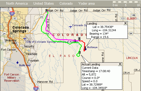
Green = Actual Flight Track
Purple = predicted ascent
Red = predicted descent
|
Recap Info |
Launch Site - Meadow Lake Air ----------------------- Launch Point: 38.951� lat. -104.5757� long. Ascent Rate: 1100 feet per minute Descent Rate: 1350 feet per minute Altitude: 6874 feet VOR Station - Black Forest (BRK) ----------------------- Latitude: 38.9417� lat. Longitude: -104.6333� long. Magnetic Offset: -10.3� from True Degrees Predicted Landing Site ----------------------- Landing Point: 38.7544� lat. -104.3124� long. Altitude: 6500 feet Flight Time: 107 Minutes Bearing: 133.7� True Range: 19.6 Mi. Actual Landing Site ----------------------- Landing Point: 38.7299� lat. -104.3492� long. Bearing: 141.3� True Range: 19.5 Mi. Difference from Predicted to Actual Landing Site -------------------------------------------------- Bearing: 229.5� True Range: 2.6 Mi. all values are predicted except for the last two entries |
LAUNCH DATE: October 19, 2002
LAUNCH TIME: 09:06 am MDT, 15:06 UTC
LAUNCH SITE: Meadow Lake Airport (Directions)
Frequencies:
All Balloon Frequencies Tentative
- HF Net during Flight
- 7228 KHz starting at 14:30 UTC (8:30am MDT)
-
Cross Band Repeater
- Input 445.975 MHz
- Output 147.555 MHz
- APRS failed
- APRS on the stand alone beacon
- 144.340 MHz
- ID = W5VSI-11
- Digi = EOSS60
- Node = BALNOD
-
Beacon
- 145.600 MHz
-
ATV
- 426.250 MHz (AM)
-
Tracking and Recovery Operations
- 448.450 MHz (100 Hz PL tone) courtesy of PPFMA
- 146.550 MHz simplex (same simplex for field and launch ops)
- Simplex at Launch Site
- 146.550 MHz (same simplex for field and launch ops)
Text Recaps:
(send in your comments)
- Mike Manes notes achievements for EOSS-60
Photos:
send in your photos
Charts:
- N�KKZ charts - generated from the KPC3 log files
Cross Band Repeater Log
It's so good, it needs its own page to do it justice
Longest distance QSO
- Between
- KC�CNT Mike Doe in Douglas, WY
- N0KQX Dale Urban in Garden City, KS
- @ 400 miles
- 10:23 MDT
Tracking and Recovery Recap:
Here is Paul Ternlund's spread sheet analysis of bearings obtained from the tracking and recovery team on this flight.
Data Files:
The complete ground station log shows all packet activity received at the EOSS ground station at Meadow Lake Airport. This includes digipeated packets from stations other than the balloon payload.
The full KPC3 log shows walking about pre-launch and the payload meandering about post touchdown as well as the brief snippet of a helicopter flight back to the tracking and recovery teams.
Text files:
- Complete Ground Station Log - all traffic on packet
- Flight Log - $GPGGA and $GPRMC
- The full KPC3 Log - all $GPGGA packets
Spread Sheet files (comma delimited)
- Flight Log - $GPGGA and $GPRMC
- The full KPC3 Log - all $GPGGA packets
Tracking and Recovery
Grid Placement:
| Location | X coord | Y coord |
| Launch point | 33 | 63.5 |
| Punkin Center | 80 | 55 |
| Colorado Springs | 20 | 55 |
| Burnt Mill | 0 | 21 |
| Karval | 89 | 47 |
| Landing point | 55 | 44 |
Experiments:
EOSS-60 will be in support of the Jamboree on the Air (JOTA) Boy Scouts of America event. Details will be added as they arrive.
Information is available on the Scout's JOTA Web Page
Here's the Flyer being posted to advertise this event.
Radio Coverage for EOSS-60 Cross Band Repeater
Coverage at 95,000 feet ASL

Light Green - (good packet reception) APRS
Red - The 0.40 uV threshold - voice may be possible outside of this zone but will be noisy
This plot generated by Radio Mobile