
EOSS Upcoming Flights
-
04/20/2024 - 00:00 to 23:45
-
04/27/2024 - 00:00 to 23:45
-
05/04/2024 - 00:00 to 23:45
-
05/18/2024 - 07:00 to 14:30
-
08/03/2024 - 00:00 to 23:45
-
10/19/2024 - 00:00 to 23:45
-
11/02/2024 - 00:00 to 23:45
-
11/09/2024 - 00:00 to 23:45
Recap of EOSS-159/160
![]() 03/02/2012 15:50 (CDT): Working on SamCam2 Pictures
03/02/2012 15:50 (CDT): Working on SamCam2 Pictures
Flight Coordinator EOSS-159: Russ Chadwick
Flight Coordinator EOSS-160: Rob Wright
LAUNCH DATE: March 12th, 2011 (wx delay +1 day)
LAUNCH TIME:
- EOSS-159: 6:50 am MST (13:50 UTC)
- EOSS-160: 7:10 am MST (14:10 UTC)
LAUNCH SITE: Windsor, Colorado (Click Here for directions)
Pre-flight Prediction and Actual Tracks
E0SS-159

Blue = Actual Track
Green = Predicted Ascent Phase
Red = Predicted Descent Phase
Map made with MapPoint
Prediction made with Balloon Track

Green Track = Ascent
Red Track = Descent
Prediction and Actual tracks made with Balloon Track
Maps by Google Earth
Map Files available in the Data Section below
Launch Site - Windsor
-----------------------
Launch Point: 40.47367� lat.   -104.96233� long.
Grid: X=-57.50 Y=40.57
Ascent Rate: 1329 feet per minute
Descent Rate: 950 feet per minute
Altitude: 4931 feet
Predicted Landing Site
-----------------------
Landing Point: 40.37268� lat.  -103.26111� long.
Grid: X=31.9 Y=33.6
Altitude: 4500 feet
Flight Time: 114 Minutes
Bearing: 93.9� True
Range: 89.7 Mi.
Actual Landing Site
-----------------------
Landing Point: 40.45922� lat.  -103.73508� long.
Grid: X=7.0 Y=39.6
Bearing: 90.5� True
Range: 64.473 Mi.
Difference from Predicted to Actual Landing Site
--------------------------------------------------
Bearing: 283.6� True
Range: 25.623 Mi.
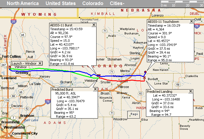
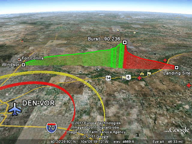
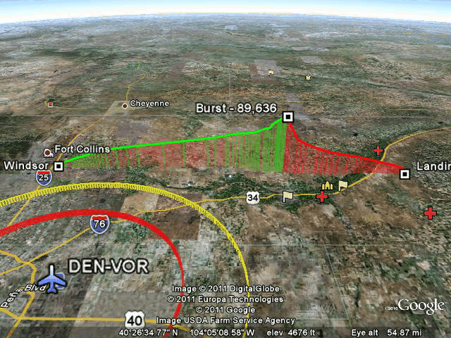
E0SS-160 AE0SS-11
Blue = Actual Track
Green = Predicted Ascent Phase
Red = Predicted Descent Phase
Map made with MapPoint
Prediction made with Balloon Track
Green Track = Ascent
Red Track = Descent
Prediction and Actual tracks made with Balloon Track
Maps by Google Earth
Map Files available in the Data Section below
Launch Site - Windsor
-----------------------
Launch Point: 40.47367� lat.   -104.96233� long.
Grid: X=-57.50 Y=40.57
Ascent Rate: 1329 feet per minute
Descent Rate: 950 feet per minute
Altitude: 4931 feet
Predicted Landing Site
-----------------------
Landing Point: 40.37232� lat.  -103.16488� long.
Grid: X=37.0 Y=33.6
Altitude: 4500 feet
Flight Time: 126 Minutes
Bearing: 93.7� True
Range: 94.7 Mi.
Actual Landing Site
-----------------------
Landing Point: 40.4572� lat.  -103.15419� long.
Grid: X=37.5 Y=39.4
Bearing: 90.1� True
Range: 94.986 Mi.
Difference from Predicted to Actual Landing Site
--------------------------------------------------
Bearing: 5.5� True
Range: 5.889 Mi.
E0SS-160 K0SCC-11

Blue = Actual Track
Green = Predicted Ascent Phase
Red = Predicted Descent Phase
Map made with MapPoint
Prediction made with Balloon Track
Green Track = Ascent
Red Track = Descent
Prediction and Actual tracks made with Balloon Track
Maps by Google Earth
Map Files available in the Data Section below
Final Pre-Flight Prediction is available here
Final Pre-Flight Prediction for EOSS-159 is available here (Slightly different as it was cut away early)
Prediction History is available here
EOSS Flight Day Frequencies:
Tracking and Recovery Frequencies
- Preflight Net:
- 147.225 MHz 8 pm MDT preceding night
- 146.640 MHz will serve as a backup frequency
- Tracking and Recovery Operations
- 449.450 MHz RMRL (103.5 Hz Tone)
- 145.295 MHz (100 Hz) (possible backup repeater in Sterling - listen to Alpha for switch info and possible PL tone info)
- 145.400 MHz (123 Hz Tone) Akron KB0VJJ (another possible alternate
- Field Simplex Frequencies
- 146.550 MHz simplex (same simplex for EOSS-159 field and launch ops)
- 146.580 MHz simplex (EOSS-160)
- Two balloons close to each other on the ground may require these separate simplex frequencies.
- Repeater Coverage Pages - Listings of all repeaters available in the expected flight areas.
- There may be FRS operations see THIS PAGE for a list of channel numbers and their associated UHF Frequencies.
EOSS-159 Balloon Payload Frequencies (AirCore)
- Beacons
- 147.555 MHz
- CW ID: AE0SS
- APRS
- 144.340 MHz
- ID: KC0YA-11
- DIGI: EOSS
- Node: BALND2
- APRS Time Slotted Every 30 seconds at 0:15 and 0:45
- power up at 13 seconds past the GPS minute to properly slot telemetry
- Telemetry once a minute
- Sample Data
EOSS-160 Balloon Payload Frequencies (EOSS Fun Flight)
- Beacons
- 145.600 MHz
- CW ID: W5VSI
- 445.975 MHz
- CW ID: N0IX
- 147.420 MHz
- CW ID: K0SCC
- APRS
- 144.340 MHz
- ID: AE�SS-11
- DIGI: EOSS
- Node: BALNOD
- APRS Time Slotted Every 30 seconds at 0:00 and 0:30
- power up at 58 seconds past the GPS minute to properly slot telemetry
- Telemetry once a minute
- Sample Data
- 147.420 MHz
- ID: K0SCC-11
Video Might Be available, check http://www.eoss.tv
Various Online Live Tracking Pages
Flight Systems:
EOSS-159
| Balloon Manufacturer | Totex |
| Balloon Type | latex |
| Balloon Size | 3000 g |
| Neck Load | 26.3 LBS. |
| Neck Lift | 31.2 LBS. |
| Ascent Rate | 1329 fpm estimated |
| Descent Rate | 950 fpm estimated |
| Parachute | 10 ft. |
| Peak Altitude | determined after flight |
| Launch Conditions | determined at launch |
EOSS-160
| Balloon Manufacturer | Totex |
| Balloon Type | latex |
| Balloon Size | 1200 g |
| Neck Load | 10.1 LBS. |
| Neck Lift | 13.2 LBS. |
| Ascent Rate | 1329 fpm estimated |
| Descent Rate | 950 fpm estimated |
| Parachute | 5 ft. |
| Peak Altitude | determined after flight |
| Launch Conditions | determined at launch |
Payload Configuration:
Payload Experiment Designer
EOSS-159: NOAA AirCore
The NOAA AirCore experiment is a regular passenger aboard EOSS balloons. A pretty good overview of this system can be seen on our recap pages for EOSS-102. Each time the experiment is flown it is reved with upgrades and changes but the concept has remained constant throughout the experiment's history with us. See the RECAP for EOSS-152 to get a feel for this experiment.
EOSS-160: EOSS Systems qualification
New HD video camera
New APRS/RF Beacon system (K0SCC-11)
New RF Beacon (N0IX)
Experimenters are welcome to submit websites for linking or overviews which I will post on a page on the EOSS website.
Internet Gateway Stations:
as seen on Findu.Com
EOSS-159, KC0YA-11
- KB0TVJ - Russ Chadwick, Boulder, CO
- KB0TVJ-4 - Russ Chadwick, Ground Station
- KC0D-3 - Mark Patton, Foxfield, CO
- KC0VJE - Louis Perley, Nunn, CO
- N0EB-1 - Richard Beggs, Thornton, CO
- N0IX-12 - Doug Gentgas, Tracking and Recovery team mobile i-Gate
- N0PSJ - Christopher Holmes, Arvada, CO
EOSS-160, AE0SS-11
- KC0D-3 - Mark Patton, Foxfield, CO
- KB0TVJ-4 - Russ Chadwick, Ground Station
- KC0VJE - Louis Perley, Nunn, CO
- N0EB-1 - Richard Beggs, Thornton, CO
- N0IX-12 - Doug Gentgas, Tracking and Recovery team mobile i-Gate
- N0PSJ - Christopher Holmes, Arvada, CO
- KB0TVJ - Russ Chadwick, Boulder, CO
EOSS-160, K0SCC-11
- KC0NEV-0 - Ronald Thomas, Longmont, CO
- KC0VJE - Louis Perley, Nunn, CO
EOSS wishes to express our sincere appreciation to the stations above who iGated the balloon APRS telemetry onto the internet. Did you know I publish predictions for i-gates? I keep a list of everyone who has ever i-gated an EOSS balloon flight. You're all in the list so if you're wondering when the balloon will pop up over your horizon, check out this page for future flights. Currently predictions are being made for 30 i-gates.
We are relying heavily on real time position information available on the net to allow the FAA controllers to have up to the minute location data to assist them in air traffic control.
Redundant stations for the balloon iGating provide excellent coverage. If you are able to iGate we invite you to join the Internet Gateway Team. Contact me (webmaster@eoss.org) to be put in touch with the coordinator. By joining the team, you are giving peace of mind to the iGate coordinator for that flight. He knows you'll be there and he can rely on you.
Naturally, anyone can iGate data onto the net and even if you aren't a member of the team we will welcome your contribution to the internet based tracking effort. If you callsign appears on the findu.com log, you'll be shown as a contributing station as those above are.
Having more than one station covering each APRS beacon means that should a station drop out momentarily, the others can often maintain the data flow.
Thanks again guys! The FAA (and EOSS) are very grateful for your assistance in this endeavor.
Future I-Gaters:
Check out the EOSS I-Gate page for information on how to participate and why we need you.
Current I-Gate Stations:
Guys, the prediction program used to determine the track of the balloon prior to flight can now output a prediction for the Rise, Closest Approach or maximum elevation, and Set of the balloon for each of your stations. I have posted a prediction page for stations that I have been able to discover geographic coordinates. See the I-Gate prediction page for an example. The page will not be updated daily, however, it will be updated the evening prior to flight for I-gate planning purposes.
I have often been asked by iGaters when they should expect to either start receiving signals (AOS) or expect to see those signals disappear (LOS). This prediction page should answer all those questions for you.
Tracking and Recovery
Alpha News
EOSS 159 will be first to launch. We will track it, and observe the landing site. Jack from NOAA wants to run the recovery for his payload. We will contact the landowner, will NOT shut off the valve (unless specifically requested) and will move on to EOSS 160. Larry, K0ANI, will shadow the NOAA tracking team and advise us on their status. Jack�s crew is 7 for 7 on previous launches, but on some they have simply followed us to establish the last mile. We have about 10 teams, so we might leave one team behind, away from the landing site i n case something goes amiss.
EOSS160 will have several new beacons and APRS devices for flight testing. Alpha will ask the various teams to be responsible for tracking the beacons and APRS devices. Initially, we ask the builders to track their own payloads. Provide reports on these beacons during the flight.
Thanks to the efforts of Mike, W9CN, there will be some new members at the launch site. Jim, K0TOR, will work with them to show them the ropes. If they come to the recovery sites, please welcome them. Bob Elliott, AB0BB and Aaron Cathcart, N0WAR.
There will be two flights, one 3000 gram balloon (EOSS 159) and a 1200 gram balloon (EOSS160). They will be launched within 20 minutes of each other . EOSS 159 will be cut down at 80-85K and will land about 12 (estimate) miles short of the prediction. EOSS 160 will land in the predicted area. Try to locate landowners early so we can leave the EOSS 159 site and move to the EOSS recovery area.
Breakfast
- McDonalds in Ft. Morgan
- Arrive: 05:45 to 06:00
- Depart: 06:00
If you want breakfast and to see the happy, early-morning faces, trackers will meet at McDonald�s in Ft. Morgan between 05:45 and 06:00. Plan to leave for the recovery at 6:00 for a 6:50 launch. This is a long double flight. Trackers should meet at breakfast site or in the predicted landing area. Mark and I will bypass breakfast and go directly to the predicted landing area.
Grid
Location Grid X Grid Y Hwy 14 & 71 West 10 50
Tactical Call Signs
Tactical
Call sign
Name
Notes
Alpha
WA0GEH, KC0D
Marty, Mark
Tracking and Recovery Coordinator
Bravo
WA9WWS, KD0MSP
Don, Anthony
Tracker, Anthony�s Second Flight
Charlie
KB0LP
Dave
Tracker
Delta
N0IX, KI6IKC
Doug, Scott
Tracker
Echo
WB0DKT, KC0ZIE
Glenn, Darren, +2
Tracker, The Big White Bus is Back!
Foxtrot
W0CBH
Benjie & Rosie
Launch Coordinator, Tracker
Golf
N0NDM
Larry
Launch Coordinator, Tracker
Hotel
KB0YRZ
Chris +1
Tracker
India
K0SCC
Steve, Daryl, Parker, Jim
Trackers, Peregrine
Juliet KC0RPS Jim Tracker Kilo
W9CN
Mike, Miles
Tracker
Lima
KC0UUO
Rob
Tracker, el Presidente
Text Recaps
Brad Miskimen, N5LUL, from Amarillo, TX sent this audio capture of the W5VSI beacon and some APRS data
Photos
Launch Site
- by Nick Hanks, N0LP
SamCam2 Airborne (look angles)
Ascending Descending Up Up Horizon Horizon Down Down Recovery Site
- by Jim Langsted, KC0RPS
- by Mike Pappas, W9CN
Audio
none
Video
|
Launch of EOSS-160 |
|
by Nick Hanks, N0LP |
|
EOSS-160 Recovery Area |
|
by Mark Patton, KC0D |
|
EOSS-160 Balloon Expansion |
|
by SamCam2 (W5VSI udpate) |
Data
EOSS-159, KC0YA-11
Text
- eoss-159_kc0ya-11_findu.txt - Findu Log
- eoss-159_kc0ya-11_findu_ts.txt - Findu Log with findu timestamps
- eoss-159_kc0ya-11_findu_airborne.txt - airborne only from Findu Log
- not yet available - Onboard KPC3 Log with annotation by kc0ya.
Spread Sheets
- eoss-159_kc0ya-11_Flight_Data.csv - airborne only findu Log ripped to spreadsheet format
- eoss-159_kc0ya-11_Telem_Data.csv - KPC3 Telemetry log
Mapping Files
- eoss-159_kc0ya-11_recap.ptm - MapPoint file of the above recap
- EOSS-159_track.kml - Google Earth Track of the flight
- EOSS-160_predict_track.kml - Google Earth Track of the predicted flight path (same for both 159 and 160)
EOSS-160, AE0SS-11
Text
- eoss-160_ae0ss-11_findu.txt - Findu Log
- eoss-160_ae0ss-11_findu_ts.txt - Findu Log with findu timestamps
- eoss-160_ae0ss-11_findu_ts.txt - airborne only from KPC3 Log (down to 9800 ft. ASL)
- eoss-160_ae0ss-11_kpc3_log.txt - Onboard KPC3 Log with annotation by w5vsi.
Spread Sheets
- eoss-160_ae0ss-11_Flight_Data.csv - airborne only KPC3 Log ripped to spreadsheet format
- eoss-160_ae0ss-11_Telem_Data.csv - KPC3 Telemetry log
Mapping Files
- eoss-160_ae0ss-11_recap.ptm - MapPoint file of the above recap
- EOSS-160_track.kml - Google Earth Track of the flight
- EOSS-160_predict_track.kml - Google Earth Track of the predicted flight path (same for both 159 and 160)
EOSS-160, K0SCC-11
Text
- eoss-160_k0scc-11_findu.txt - Findu Log
- eoss-160_k0scc-11_findu_ts.txt - Findu Log with findu timestamps
- eoss-160_k0scc-11_findu_fixed.txt - airborne only from Findu Log anomalies removed for charting (down to ~9800 ft. ASL)
Spread Sheets
- eoss-160_k0scc-11_Flight_Data.csv - airborne only KPC3 Log ripped to spreadsheet format
Mapping Files
- eoss-160_k0scc-11_recap.ptm - MapPoint file of the above recap
- eoss-160_k0scc-11_track.kml - Google Earth Track of the flight
- EOSS-160_predict_track.kml - Google Earth Track of the predicted flight path (same for both 159 and 160)
Charts
by Nick Hanks, N0LP