
EOSS Upcoming Flights
-
04/27/2024 - 00:00 to 23:45
-
05/04/2024 - 00:00 to 23:45
-
05/18/2024 - 07:00 to 14:30
-
08/03/2024 - 00:00 to 23:45
-
10/19/2024 - 00:00 to 23:45
-
11/02/2024 - 00:00 to 23:45
-
11/09/2024 - 00:00 to 23:45
Recap of EOSS-135
![]() 03/02/2012 15:50 (CDT): finished
03/02/2012 15:50 (CDT): finished
|
|
| It's cold out here but, we're still havin' fun |

Flight Coordinator: Rob Wright, KC0UUO (kcouuo@eoss.org)
LAUNCH DATE: February 28th, 2009 (wx +1)
LAUNCH TIME: 07:00 MST (14:00 UTC)
LAUNCH SITE: Windosor, CO (see directions)
Pre-flight Prediction and Actual Tracks
Flight Tracks and data files will be updated when the KPC3 log files from KC0YA-11 arrive

Blue = Actual Track
Green = Predicted Ascent Phase
Red = Predicted Descent Phase
Map made with MapPoint
Prediction made with Balloon Track
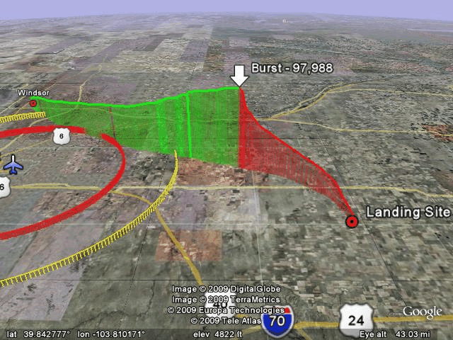
Green Track = Ascent
Red Track = Descent
Prediction and Actual tracks made with Balloon Track
Maps by Google Earth
Launch Site - Windsor
-----------------------
Launch Point: 40.47367� lat.   -104.96233� long.
Grid: X=-56.56 Y=100.11
Ascent Rate: 1400 feet per minute
Descent Rate: 950 feet per minute
Altitude: 4931 feet
Predicted Landing Site
-----------------------
Landing Point: 39.67457� lat.  -103.33854� long.
Grid: X=29.1 Y=44.9
Altitude: 4500 feet
Flight Time: 121 Minutes
Bearing: 122.2� True
Range: 102.0 Mi.
Actual Landing Site
-----------------------
Landing Point: 39.53628� lat.  -103.38437� long.
Grid: X=26.7 Y=35.4
Bearing: 127.3� True
Range: 105.61 Mi.
Difference from Predicted to Actual Landing Site
--------------------------------------------------
Bearing: 194.3� True
Range: 9.857 Mi.
Prediction History is available here
Final Pre-Flight Prediction is available here
Payload Experiment Designer
- EOSS - systems test, fun flight
- Colorado University - Balloon Sats (3)
EOSS Flight Day Frequencies:
Tracking and Recovery Frequencies
- Preflight Net:
- 147.225 MHz 8 pm MST the evening prior to flight day
- 145.160 MHz simulcast in the Springs
- 145.460 MHz simulcast in Boulder
- 146.640 MHz will serve as a backup frequency
- 147.225 MHz 8 pm MST the evening prior to flight day
-
Tracking and Recovery Operations
- 449.450 MHz RMRL (103.5 Hz Tone)
- 447.575 MHz CRA (107.2 Hz tone)
- 146.550 MHz simplex (same simplex for field and launch ops)
- Repeater Coverage Pages - Listings of all repeaters available in the expected flight areas.
- There may be FRS operations see THIS PAGE for a list of channel numbers and their associated UHF Frequencies.
EOSS-135
- Beacons
- 145.600 MHz
- CW ID: K0ANI
- 145.600 MHz
- APRS
- 145.600 MHz
- ID: K0ANI-11
- 144.340 MHz
- ID: KC0YA-11
- DIGI: EOSS
- Node: BALND2
- APRS Time Slotted Every 30 seconds at 0:15 and 0:45
- power up at 13 seconds past the GPS minute to properly slot telemetry
- Telemetry once a minute
- Sample Data
- 145.600 MHz
- 147.535 MHz
- ID: K0SCC-11
- 147.555 MHz
- ID: W0WYX
- RMRL Cross Band Repeater GPS
- Cross Band Repeater
- Input: 445.975 MHz
- Output: 147.555 MHz
- ID: W0WYX
- ATV
- 426.250 MHz AM
- ID: AE0SS
- GPS overlay
- de-spun 3G payload w/ B-LAN receiver
Flight Systems:
EOSS-135
| Balloon Manufacturer | Kaysam |
| Balloon Type | latex |
| Balloon Size | 3000 gram |
| Neck Load | 25.23 lbs. |
| Neck Lift | 29.6 lbs |
| Ascent Rate | 1400 fpm estimated |
| Descent Rate | 950 fpm estimated |
| Parachute | 10 ft |
| Peak Altitude | determined after flight |
| Launch Conditions | determined at launch |
Payload Configuration:
Tracking and Recovery Info:
Breakfast
Trackers on your own or at the McDonalds (I-70 exit 359 south side) at 05:00 to 05:15. Departure for tracking locations no later than 06:00 from Limon.
Grid
|
Location |
Grid X |
Grid Y |
|
Last Chance (Intersection of SR71 & US36) |
15.5 |
49.5 |
| TrackPoint Test = 40� 15' N, 103� 30' W | 20.4 | 84.5 |
Tactical Call Signs
|
Tactical |
Callsign |
Name |
Notes |
|
Alpha |
WG0E |
Colin & Tim (no call) |
Tracking and Recovery Coordinator |
|
Bravo |
KB0YRZ |
Chris |
|
|
Charlie |
W9CN |
Mike |
|
|
Delta |
WB0DKT, WB6KDF, & KG6HXM |
Glenn, Loren, Sam & Suzanna |
|
|
Echo |
KC0RPS, N0SSW, & N0NFW |
Jim, Harlan & George |
|
|
Foxtrot |
K0SCC |
Steve & Daryl |
|
|
Golf |
WA0GEH, KC0D |
Marty & Mark |
|
| Hotel | KC0UUO | Rob | |
|
|
N0NDM, W0CBH |
Larry & Benjie |
Launch Coordinator�tentative tracking |
|
|
AE0SS |
Nick |
Ground Station |
Internet Gateway Stations:
as seen on Findu.Com
EOSS-135
KC0YA-11
- KB0TVJ - Russ Chadwick, at the launch site
- KB7ZZS - Michael Conrod, Lakewood, CO
- N0EB-1 - Richard Beggs, Northglenn, CO
- N0PSJ - Christopher Holmes, Arvada, CO
- N0SPB-10 - Shaun Bryant, Commerce City, CO (formerly:KC0ZLS)
- N0SPB - Shaun Bryant, Commerce City, CO
- AB0XK - Robert Roe, Russell, KS
- AB0XK-8 - Robert Roe, Russell, KS
- N0KOU-7 - Dean Wheeler, Russell, KS
K0ANI-11
- K0UT-15 - Bill Beach, Ft. Collins, CO
- N0SPB - Shaun Bryant, Commerce City, CO
- N0SPB - Shaun Bryant, Commerce City, CO
K0SCC-11
- KB0TVJ-4 - Russ Chadwick, Boulder, CO
- KB0TVJ - Russ Chadwick, at the launch site
W0WYX
- KC0D-3 - Mark Patton, Foxfield, CO
- N0SPB-10 - Shaun Bryant, Commerce City, CO (formerly:KC0ZLS)
Michael, KB7ZZS, welcome aboard. I've added you to the igate roster and predictions for your location will appear from now on at the iGate prediction page.
Dean,N0KOU, I found an old packet for you (2007) and added that location to the database so predictions for that location will now appear on the iGate prediction page. If this location is wrong let me know and I can correct it. But, from Russell to our balloons a mile this way or that won't have much impact on the predicted data. Still if you wish to correct the database let me know. Our next flight is March 28th, and you'll see "your location" being predicted for approximately 7 days prior to flight.
Robert, AB0XK, nice to have you on board again.
To all the Colorado stations, thanks guys. We REALLY need all this support to maintain our excellent relationship with the FAA. They need to have access to accurate live data in order to grant us permission to fly our heavy systems.
EOSS wishes to express our sincere appreciation to the stations above who iGated the balloon APRS telemetry onto the internet. Did you know I publish predictions for i-gates? I keep a list of everyone who has ever i-gated an EOSS balloon flight. You're all in the list so if you're wondering when the balloon will pop up over your horizon, check out this page for future flights. Currently predictions are being made for 29 i-gates.
We are relying heavily on real time position information available on the net to allow the FAA controllers to have up to the minute location data to assist them in air traffic control.
Redundant stations for the balloon iGating provide excellent coverage. If you are able to iGate we invite you to join the Internet Gateway Team. Contact me (webmaster@eoss.org) to be put in touch with the coordinator. By joining the team, you are giving peace of mind to the iGate coordinator for that flight. He knows you'll be there and he can rely on you.
Naturally, anyone can iGate data onto the net and even if you aren't a member of the team we will welcome your contribution to the internet based tracking effort. If you callsign appears on the findu.com log, you'll be shown as a contributing station as those above are.
Having more than one station covering each APRS beacon means that should a station drop out momentarily, the others can often maintain the data flow.
Thanks again guys! The FAA (and EOSS) are very grateful for your assistance in this endeavor.
Future I-Gaters:
Check out the EOSS I-Gate page for information on how to participate and why we need you.
Current I-Gate Stations:
Guys, the prediction program used to determine the track of the balloon prior to flight can now output a prediction for the Rise, Closest Approach or maximum elevation, and Set of the balloon for each of your stations. I have posted a prediction page for stations that I have been able to discover geographic coordinates. See the I-Gate prediction page for an example. The page will not be updated daily, however, it will be updated the evening prior to flight for I-gate planning purposes.
I have often been asked by iGaters when they should expect to either start receiving signals (AOS) or expect to see those signals disappear (LOS). This prediction page should answer all those questions for you.
Text Recaps
- Launch Operations - by Benjie Campbell, W0CBH
Photos
Launch Site
- by Nick Hanks, N0LP
- by Robert Slate, N0TQN
Airborne SamCam2
Altitude captions determined by cross correlation with time stamps in APRS and camera Exif data. Camera time offset calculated by observing liftoff and burst events. Bottom line, it's close but not exact by any means.
- Looking Up
- Looking Out, at the Horizon
Recovery Site
- by Mark Patton, KC0D
- by Miles Pappas
- by Colin Glennan, WG0E
- by Chris Krengel, KB0YRZ
Lunch
- by Jim Langsted, KC0RPS
Audio
recorded. will be posted when edited.
Video
Time Lapse from SamCam2
Mike Manes has built a really fantastic enclosure for the SamCam2. See the SamCam2 Hardware Page for details. Simply put, the enclosure rotates to three positions, looking down, looking towards the horizon and looking straight up. At each position the camera takes a photo. Time lapse movies made from the photos from the horizon and down angles do not make for much to look at, however, the up angle is fun to condense into a time lapse as it shows the a pretty plain background with the balloon and support strings. And as you will see when you view the movie you can watch the expansion of the balloon. Pretty cool.
Nick Hanks Launch Site video
Data
EOSS-135
KC0YA-11
Text
- eoss-135_kc0ya-11_findu.txt - Findu data file
- eoss-135_kc0ya-11_findu_ts.txt - Findu data file with findu time stamps
Spread Sheets
- eoss-135_kc0ya-11_Flight_Data.csv - findu data file above ripped to CSV (will be updated)
- eoss-135_kc0ya-11_Telem_Data.csv - telemetry from the KPC3
Mapping Files
- eoss-135_track.kml - Google Earth KML file of the actual track
- eoss-135_predict_track.kml - Google Earth KML file of the predicted track
- eoss-135_kc0ya-11_recap.ptm - MapPoint file of the recap image above
K0ANI-11
Text
- eoss-135_k0ani-11_findu.txt - Findu data file
- eoss-135_k0ani-11_findu_ts.txt - Findu data file with findu time stamps
Spread Sheets
Mapping Files
K0SCC-11
Text
- eoss-135_k0scc-11_findu.txt - Findu data file
- eoss-135_k0scc-11_findu_ts.txt - Findu data file with findu time stamps
Spread Sheets
Mapping Files
W0WYX
Text
- eoss-135_w0wyx_findu.txt - Findu data file
- eoss-135_w0wyx_findu_ts.txt - Findu data file with findu time stamps
Spread Sheets
Mapping Files
Charts
- nothing yet