
EOSS Upcoming Flights
-
04/20/2024 - 00:00 to 23:45
-
04/27/2024 - 00:00 to 23:45
-
05/04/2024 - 00:00 to 23:45
-
05/18/2024 - 07:00 to 14:30
-
08/03/2024 - 00:00 to 23:45
-
10/19/2024 - 00:00 to 23:45
-
11/02/2024 - 00:00 to 23:45
-
11/09/2024 - 00:00 to 23:45
4 Day Prediction
EOSS-66
This is a prediction for a flight Saturday morning 3/May/2003
prediction data acquired 29/April/2003 15:37 MDT
Predictions become more accurate the closer to launch time.
Green = Ascent Phase
White = Float (if used)
Red = Descent Phase
Flight predictions made using Balloon Track for Windows
Mapping Software - Microsoft MapPoint 2002
APRS software - APRS-Plus
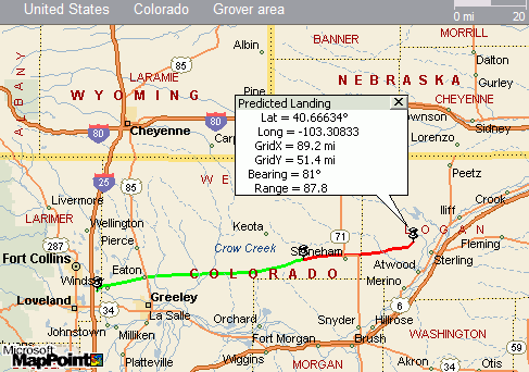
Prediction
Balloon Track for Windows                                Version 1.8.2
__________________________________________________________________________
Flight Prediction
Tuesday, April 29, 2003            EOSS-66      Profile_03_05_03_1200Z.dat
3:37:56 PM                         Windsor                    wbaltrak.ini
__________________________________________________________________________
Winds DataFile
-----------------------
Station: UNK
Date: 1200Z 03 05 2003
DataFile Status: Intact
Intact Records: 18
Corrupt Records: 0
Launch Site - Windsor
-----------------------
Launch Point: 40.4737� lat.   -104.9635� long.
Ascent Rate: 1001 feet per minute
Descent Rate: 864 feet per minute
Altitude: 5020 feet
VOR Station - Gill
-----------------------
Latitude: 40.51� lat.
Longitude: -104.55� long.
Magnetic Offset: -10.8� from True Degrees
Maximums Enroute
-----------------------
Distance to LOS: 403.5 Mi.
Maximum Range: 87.8 Mi.
Maximum Winds: 102.4 mph from 268� at 39,072 feet altitude
Burst Data
-----------------------
Burst Point: 40.5983� lat.  -103.883� long.
Burst Time: 89.9 minutes
Burst Altitude: 95,000 feet
Burst Bearing: 81.0�
Burst Range: 57.3 Mi.
Predicted Landing Site
-----------------------
Landing Point: 40.6663� lat.  -103.3083� long.
Altitude: 4501 feet
Flight Time: 135 Minutes
Bearing: 80.7� True
Range: 87.8 Mi.
__________________________________________________________________________
Bear Rng  EL. Vertical                      Dist. Bearing Range VOR
Time      Alt   Deg  Mi. Deg   FPM   Latitude  Longitude  to LOS   Mag    NM   ID
-----------------------------------------------------------------------------------------
< 1   5070   57    1  55   1001  40.4737   -104.9634    10     253    19   GLL
1   6486   57    1  55   1001  40.4752   -104.9604    52     253    19   GLL
3   8212   47    1  44   1001  40.4798   -104.9548    76     254    19   GLL
5  10056   46    1  41   1001  40.4846   -104.9488    95     255    18   GLL
7  12011   48    2  39   1001  40.4895   -104.9403   112     255    18   GLL
9  14081   55    2  36   1001  40.4931   -104.9267   128     256    17   GLL
11  16286   63    3  33   1001  40.4953   -104.9084   143     256    16   GLL
14  18645   68    5  30   1001  40.4986   -104.8838   157     257    15   GLL
16  21198   70    6  27   1001  40.5034   -104.8537   171     258    14   GLL
19  23980   72    8  24   1001  40.5091   -104.8211   185     259    12   GLL
22  27041   73   10  22   1001  40.5176   -104.7790   200     262    10   GLL
25  30472   74   13  20   1001  40.5259   -104.7224   215     266     8   GLL
29  34409   76   17  18   1001  40.5321   -104.6423   231     277     4   GLL
34  39072   79   24  15   1001  40.5401   -104.5151   248      31     2   GLL
40  44957   82   34  12   1001  40.5443   -104.3239   269      68    11   GLL
48  53264   83   43  12   1001  40.5479   -104.1450   295      72    19   GLL
62  67480   82   52  13   1001  40.5763   -103.9884   336      70    26   GLL
81  86388   81   56  15   1001  40.5973   -103.9176   384      69    29   GLL
90  95000   81   57  16   1001  40.5983   -103.8830   404      69    31   GLL
91  86388   81   58  15   6028  40.5985   -103.8772   385      69    31   GLL
96  67480   81   59  11   3866  40.6039   -103.8589   338      69    32   GLL
101  53264   81   62   8   2753  40.6141   -103.8019   297      69    35   GLL
105  44957   81   66   6   2257  40.6154   -103.7225   271     309    37   AKO
108  39072   82   71   5   1960  40.6169   -103.6247   250     315    34   AKO
111  34409   82   75   4   1754  40.6209   -103.5519   233     320    33   AKO
113  30472   82   77   3   1601  40.6243   -103.5017   217     323    32   AKO
115  27041   82   79   2   1482  40.6294   -103.4633   202     326    31   AKO
118  23980   82   81   2   1386  40.6352   -103.4327   188     329    31   AKO
120  21198   82   82   2   1306  40.6393   -103.4076   174     331    31   AKO
122  18645   81   84   1   1238  40.6429   -103.3831   160     333    31   AKO
124  16286   81   85   1   1180  40.6454   -103.3621   146     335    31   AKO
126  14081   81   86   1   1129  40.6471   -103.3459   132     336    30   AKO
128  12011   81   86   1   1083  40.6502   -103.3332   117     338    31   AKO
130  10056   81   87   1   1043  40.6548   -103.3249   100     338    31   AKO
131   8212   81   87  -1   1006  40.6596   -103.3188    82     339    31   AKO
133   6486   81   88  -1    974  40.6642   -103.3129    60     340    31   AKO
135   4501   81   88  -1    938  40.6663   -103.3083     1     340    31   AKO