
EOSS Upcoming Flights
-
04/20/2024 - 00:00 to 23:45
-
04/27/2024 - 00:00 to 23:45
-
05/04/2024 - 00:00 to 23:45
-
05/18/2024 - 07:00 to 14:30
-
08/03/2024 - 00:00 to 23:45
-
10/19/2024 - 00:00 to 23:45
-
11/02/2024 - 00:00 to 23:45
-
11/09/2024 - 00:00 to 23:45
Flight Recap for EOSS-165
![]() 03/02/2012 15:50 (CDT): Launch Site and Lift Off videos posted. Flight video by tomorrow maybe.
03/02/2012 15:50 (CDT): Launch Site and Lift Off videos posted. Flight video by tomorrow maybe.
|
Patrolling skies over landing site |

|
Flight Coordinator: Rob Wright, KC0UUO
LAUNCH DATE: June 11th, 2011 (wx delay +1 day)
LAUNCH TIME: 07:10 am MDT (13:10 UTC)
LAUNCH SITE: Windsor, Colorado (Click Here for directions)
Pre-flight Prediction and Actual Tracks
PRE-DISASTER
E0SS-165 AE0SS-11

Blue = Actual Track
Green = Predicted Ascent Phase
Red = Predicted Descent Phase
Map made with MapPoint
Prediction made with Balloon Track

Green Track = Ascent
Red Track = Descent (NO DESCENT TRACK)
Prediction and Actual tracks made with Balloon Track
Maps by Google Earth
Above Map Files available in the Data Section below
Launch Site - Windsor
-----------------------
Launch Point: 40.47367� lat.   -104.96233� long.
Grid: X=-17.42 Y=5.57
Ascent Rate: 1329 feet per minute
Descent Rate: 950 feet per minute
Altitude: 4931 feet
Predicted Landing Site
-----------------------
Landing Point: 41.02571� lat.  -104.01477� long.
Grid: X=32.1 Y=43.7
Altitude: 4500 feet
Flight Time: 127 Minutes
Bearing: 52.1� True
Range: 62.5 Mi.
Actual Landing Site
-----------------------
Landing Point: 40.91788� lat.  -104.4705� long.
Grid: X=8.4 Y=36.2
Bearing: 39.9� True
Range: 40.043 Mi.
Difference from Predicted to Actual Landing Site
--------------------------------------------------
Bearing: 252.8� True
Range: 24.896 Mi.
Final Pre-Flight Prediction is available here
Prediction History is available here
POST-DISASTER (Post Burst)
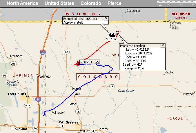
Blue = Actual Track
Red = Predicted Descent Phase
Map made with MapPoint
Prediction made with Balloon Track
Launch Site - EOSS-165 Burst Location
-----------------------
Launch Point: 40.75966� lat.   -104.70488� long.
Grid: X=-3.88 Y=25.32
Ascent Rate: 1329 feet per minute
Descent Rate: 950 feet per minute
Altitude: 101152 feet
Predicted Landing Site
-----------------------
Landing Point: 40.92962� lat.  -104.41282� long.
Grid: X=11.4 Y=37.1
Altitude: 4500 feet
Flight Time: 40 Minutes
Bearing: 52.3� True
Range: 19.2 Mi.
Actual Landing Site
-----------------------
Landing Point: 40.91788� lat.  -104.4705� long.
Grid: X=8.4 Y=36.2
Bearing: 48.2� True
Range: 16.408 Mi.
Difference from Predicted to Actual Landing Site
--------------------------------------------------
Bearing: 255.0� True
Range: 3.117 Mi.
EOSS Flight Day Frequencies:
Tracking and Recovery Frequencies
- Preflight Net:
- 147.225 MHz 8 pm MDT preceding night
- 146.640 MHz will serve as a backup frequency
- Tracking and Recovery Operations
- 449.450 MHz (103.5 Hz Tone) north track RMRL
- 146.775 MHz (114.8 Hz Tone) Cheyenne
- 147.165 MHz (114.8 Hz Tone) Albin
- Field Simplex Frequencies
- 446.100 MHz simplex
- Note: Some radios insist on incorrectly placing a negative 5 MHz offset when selecting frequencies from the simplex portion of the 70 CM band. Check your radio and if this is the case. Consider programming in this simplex frequency to a memory channel as some radios have demonstrated the annoying habit of re-inserting the offset if you momentarily shift to a repeater then return to the simplex freq. Check the operation of your radio on this simplex freq to be ready for however your radio behaves.
- Repeater Coverage Pages - Listings of all repeaters available in the expected flight areas.
- There may be FRS operations see THIS PAGE for a list of channel numbers and their associated UHF Frequencies.
- Launch Site Simplex
- 146.550 MHz
EOSS-165 Balloon Payload Frequencies
- Beacons
- 147.555 MHz
- CW ID: AE0SS
- APRS
- 144.340 MHz
- ID: AE�SS-11
- DIGI: EOSS
- Node: BALNOD
- APRS Time Slotted Every 30 seconds at 0:00 and 0:30
- power up at 58 seconds past the GPS minute to properly slot telemetry
- Telemetry once a minute
- Sample Data
Video Might Be available, check http://www.eoss.tv
Various Online Live Tracking Pages
Flight Systems:
EOSS-165
| Balloon Manufacturer | Totex |
| Balloon Type | latex |
| Balloon Size | 3000 g |
| Neck Load | 24.3 lbs. |
| Neck Lift | 28.9 lbs. |
| Ascent Rate | 1329 fpm estimated |
| Descent Rate | 950 fpm estimated |
| Parachute | 10 ft. |
| Peak Altitude | 95,000 ft. ASL estimated |
| Launch Conditions | determined at launch |
Payload Configuration:
Payload Experiment Designer
CU SGC, SHOT Workshop
Experimenters are welcome to submit websites for linking or overviews which I will post on a page on the EOSS website.
Internet Gateway Stations:
as seen on Findu.Com (listed alphabetically)
EOSS-165, AE0SS-11
- KB0TVJ - Russ Chadwick, Boulder, CO
- KB0TVJ-4 - Russ Chadwick, Ground Station
- KC0D-1 - Mark Patton, Foxfield, CO
- KC0VJE - Louis Perley, Nunn, CO
- N0EB-1 - Richard Beggs, Thornton, CO
- N0IX-12 - Doug Gentges, Tracking and Recovery Mobile iGate
- N0ZUQ-1 - Clifford Mikkelson - Windsor, CO
EOSS wishes to express our sincere appreciation to the stations above who iGated the balloon APRS telemetry onto the internet. Did you know I publish predictions for i-gates? I keep a list of everyone who has ever i-gated an EOSS balloon flight. You're all in the list so if you're wondering when the balloon will pop up over your horizon, check out this page for future flights. Currently predictions are being made for 30 i-gates.
We are relying heavily on real time position information available on the net to allow the FAA controllers to have up to the minute location data to assist them in air traffic control.
Redundant stations for the balloon iGating provide excellent coverage. If you are able to iGate we invite you to join the Internet Gateway Team. Contact me (webmaster@eoss.org) to be put in touch with the coordinator. By joining the team, you are giving peace of mind to the iGate coordinator for that flight. He knows you'll be there and he can rely on you.
Naturally, anyone can iGate data onto the net and even if you aren't a member of the team we will welcome your contribution to the internet based tracking effort. If you callsign appears on the findu.com log, you'll be shown as a contributing station as those above are.
Having more than one station covering each APRS beacon means that should a station drop out momentarily, the others can often maintain the data flow.
Thanks again guys! The FAA (and EOSS) are very grateful for your assistance in this endeavor.
Future I-Gaters:
Check out the EOSS I-Gate page for information on how to participate and why we need you.
Current I-Gate Stations:
Guys, the prediction program used to determine the track of the balloon prior to flight can now output a prediction for the Rise, Closest Approach or maximum elevation, and Set of the balloon for each of your stations. I have posted a prediction page for stations that I have been able to discover geographic coordinates. See the I-Gate prediction page for an example. The page will not be updated daily, however, it will be updated the evening prior to flight for I-gate planning purposes.
I have often been asked by iGaters when they should expect to either start receiving signals (AOS) or expect to see those signals disappear (LOS). This prediction page should answer all those questions for you.
Tracking and Recovery
Breakfast
- Johnson's Corner (Google Map)
- 2842 SE Frontage Road, Johnstown, CO 80534
- Meet at 05:00
- Head into the field at 06:00
Grid
Location
Grid X
Grid Y
Hwy 14 & 71 West 50 15 Test Coordinates 40� 45' -103� 15' 72.3 24.6
Tactical Call Signs
Tactical Callsign Name Notes Alpha KC0UUO, N0IX Rob and Doug Tracking and Recovery Coordinator Bravo KB0UBZ Ben Tracker Charlie KC0RPS, W0NFW Jim and George Trackers Delta K0SCC, WB0DKT Steve, Glenn and Parker Tracker Echo W9CN, KD0JIT Mike, Miles Trackers, Comm Coordinator Foxtrot WA9WWS, KD0MSP Don, Anthony Trackers Golf N0NDM, W0CBH Larry, Benjie Launch Coordinator, Tracker Hotel KB0LP Dave Tracker India KC0ZIE, KG6HXM Darren, Sam Trackers
Text Recaps
Benjie Campbell's take on the flight
Photos
Launch Site
- by Arlee Chadwick
- by Larry Cerney, K0ANI
- by Tim Russell, K0RUS
Recovery Site
- by Mike Pappas, W9CN
- by Jim Langsted, KC0RPS
The Sundering
AE0SS-11 gives up the ghost after a bout with post burst chaos. But, it appears it will rise again.
Ashes cannot retain their hold on AE0SS-11, it has arisen.
Audio
recorded, not posted
Video
|
Lift Off |
|
by Tim Russell, K0RUS |
|
Launch Site |
|
by Nick Hanks, N0LP |
|
Disaster at Burst |
|
by GoPro HeroHD |
Data
EOSS-165, AE0SS-11
Text
- eoss-165_ae0ss-11_findu.txt - Findu Log
- eoss-165_ae0ss-11_findu_ts.txt - Findu Log with findu timestamps
- eoss-165_ae0ss-11_airborne.txt - airborne only from KPC3 Log
- eoss-165_ae0ss-11_kpc3_ltr_log.txt - Onboard KPC3 Log with annotation by w5vsi.
Spread Sheets
- eoss-165_ae0ss-11_Flight_Data.csv - airborne only Log ripped to spreadsheet format
- eoss-165_ae0ss-11_Telem_Data.csv - KPC3 Telemetry log
Mapping Files
- eoss-165_ae0ss-11_pre_burst_recap.ptm - MapPoint file of the above pre-disaster recap
- eoss-165_ae0ss-11_post_burst_recap.ptm - MapPoint file of the above post-disaster recap
- EOSS-165_track.kml - Google Earth Track of the flight
- EOSS-165_predict_track.kml - Google Earth Track of the predicted flight path