
EOSS Upcoming Flights
-
04/20/2024 - 00:00 to 23:45
-
04/27/2024 - 00:00 to 23:45
-
05/04/2024 - 00:00 to 23:45
-
05/18/2024 - 07:00 to 14:30
-
08/03/2024 - 00:00 to 23:45
-
10/19/2024 - 00:00 to 23:45
-
11/02/2024 - 00:00 to 23:45
-
11/09/2024 - 00:00 to 23:45
Recap of EOSS-56
LAUNCH DATE: April 21, 2002
LAUNCH TIME: 08:59 MDT, 14:59 UTC
LAUNCH SITE: Windsor, Colorado (directions here)
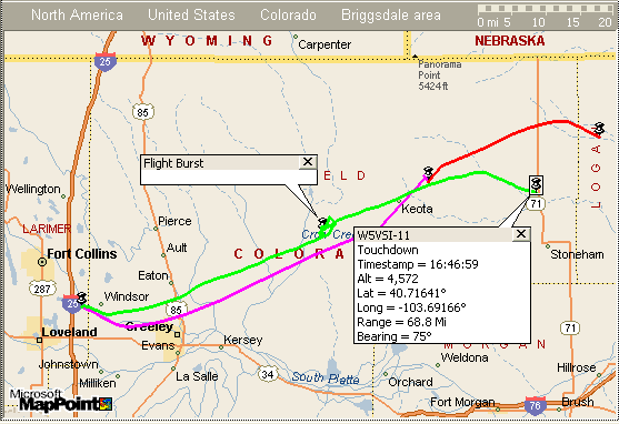
Green = Flight Track
Purple = Predicted Ascent
Red = Predicted Descent
Balloon Track for Windows                                Version 1.7.6
__________________________________________________________________________
Flight Recap
Thursday, April 25, 2002           EOSS-56avn111_Profile_02_04_21_1200Z.dat
1:24:01 AM                         Windsor                    wbaltrak.ini
__________________________________________________________________________
Winds DataFile
-----------------------
Station: UNK
Date: 1200Z 21 04 2002
DataFile Status: Intact
Intact Records: 17
Corrupt Records: 0
Grid Placement Data
-----------------------
Reference Site: Int 71-14East
Latitude: 40.6102� lat.
Longitude: -103.6769� long.
X_Offset: 55.00
Y_Offset: 33.00
Grid Origin
Latitude: 40.1323� lat.
Longitude: -104.7261� long.
Launch Site - Windsor
-----------------------
Launch Point: 40.4737� lat.   -104.9635� long.
Grid: X=-12.5 Y=23.6
Ascent Rate: 1200 feet per minute
Descent Rate: 1230 feet per minute
Altitude: 5020 feet
VOR Station - Gill(GLL)
-----------------------
Latitude: 40.51� lat.
Longitude: -104.55� long.
Magnetic Offset: -10.8� from True Degrees
Predicted Landing Site
-----------------------
Landing Point: 40.8347� lat.  -103.515� long.
Grid: X=63.3 Y=48.5
Altitude: 4500 feet
Flight Time: 107 Minutes
Bearing: 71.3� True
Range: 79.9 Mi.
Actual Landing Site
-----------------------
Landing Point: 40.7164� lat.  -103.6917� long.
Grid: X=54.1 Y=40.3
Bearing: 75.5� True
Range: 68.8 Mi.
Difference from Predicted to Actual Landing Site
--------------------------------------------------
Bearing: 228.6� True
Range: 12.3 Mi.
Frequencies:
- APRS
-
- 144.340 MHz (Payload APRS Beacon)
-
Beacon
- 147.555 MHz CW
-
Tracking and Recovery Operations
- 449.450 MHz (Rocky Mountain Radio League)
- 146.550 MHz simplex (same simplex for field and launch ops)
- Simplex at Launch Site
- 146.550 MHz (same simplex for field and launch ops)
- HF Net during Flight
- 7228 KHz Bruce NA�BR net control
Grid Layout
The western intersection of 14 and 71 (near Stoneham which is ~ 30 miles north of Brush)

- The Y = 60 line should lay on the border between Colorado and Wyoming
- Ault = 0, 31
- Peetz = 85, 57
- West Intersection of State Road 14 and State Road 71 = 55, 33
- coordinates for Nick's Grid Calculator
- N 40� 36.615'
- W 103� 40.614'
- Akron = 80, 1.5
Experiments:
Colorado University Balloon Sats. Below are links to their project proposals.
- The Flying Cockroaches (Atmospheric exposure of same at high altitude)
- Project Space Monkey (Monitor atmosphere and satellite environments)
- Mega Maid (Intensity of light vs. Temperatures at various altitudes)
- Proposal 4 (Temp, Pressure, Photography)
- Project Strangelove (Radiation vs. Altitude)
- Phatsat (Atmospheric measurements, photographic platform)
University of Wyoming will also be flying several payloads (4 so far).
Notes:
The long distance Earth-Balloon-Balloon-Earth (EBBE) packet experiment has been canceled this time out.
However, we may have a second payload in the air during the flight aboard a second balloon launched from the same site. This will offer the ability to test EBBE however the range won't be much better than digipeating through a single payload.
The second payload is on the same freq (naturally) of 144.340 MHz. The callsign will be KC0JHQ-11.
Graphs
Telemetry
Plain Text ASCII file (a compilation of several TNC Log data sources - N0TI, K0YG, W5VSI, N0KKZ)
SpreadSheets
- CSV file with $GPRMC data included
- CSV file without $GPRMC (smoother altitude plots)
- Excel file without $GPRMC some graphs included
The spread sheets were developed using a new capability in Balloon Track that will keep me better informed regarding the HISTORY of the flight as it progresses. The spread sheets now include the following fields:
- System time (time on the computer when extracting the data)
- GPS Time - Time stamp from GPS included in downlinked packet
- Altitude - from GPS
- Ascent Rate - calculated from current and previous packets
- Grid X - the X axis grid position from the EOSS tracking and recovery grid
- Grid Y - the Y axis grid position from the EOSS tracking and recovery grid
- Latitude - from GPS
- Longitude - from GPS
- Track - calculated from the current and previous packets
- Speed - calculated from the current and previous packets
- GPS Track - from the GPRMC string
- GPS Speed - from the GPRMC string
- Bearing from Launch site
- Range from Launch site
- Footprint diameter (balloon over expected landing point's altitude)
Naturally, if you select the file above that does not include the $GPRMC string data you won't be seeing any values for the GPS track and speed.
.